HISTORIX Vintage 1892 United States Map - and 50 similar items


Free Shipping
HISTORIX Vintage 1892 United States Map - 18x24 Inch Vintage Map of United State
$39.99 - $59.99
View full item details »

Shipping options
Seller handling time is 1 business day Details
FREE via to United States
Return policy
Full refund available for DOAs
Details
Purchase protection
Payment options
PayPal accepted
PayPal Credit accepted
Venmo accepted
PayPal, MasterCard, Visa, Discover, and American Express accepted
Maestro accepted
Amazon Pay accepted
Nuvei accepted
View full item details »
Shipping options
Seller handling time is 1 business day Details
FREE via to United States
Return policy
Full refund available for DOAs
Details
Purchase protection
Payment options
PayPal accepted
PayPal Credit accepted
Venmo accepted
PayPal, MasterCard, Visa, Discover, and American Express accepted
Maestro accepted
Amazon Pay accepted
Nuvei accepted
Item traits
| Category: | |
|---|---|
| Quantity Available: |
16 in stock |
| Condition: |
New |
| ASIN: |
B08LPKNTHW |
| Item Name: |
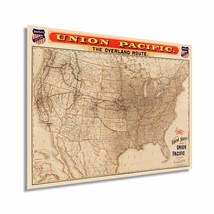
HISTORIX 1892 Map of The United States Union Pacific Overland Route |
| manufacturer: |
HISTORIX |
| Item Type Keyword: |
prints |
| Brand: |
HISTORIX |
| Unspsc Code: |
52140000 |
| sizes: |
Listing details
| Seller policies: | |
|---|---|
| Shipping discount: |
Seller pays shipping for this item. |
| Posted for sale: |
May 1 |
| Item number: |
1743620000 |
Item description
The main line of the Union Pacific Railroad was completed in 1869 and was a federally funded project that aimed to forge allegiances with California and Oregon as the nation prepared for the American Civil War outbreak. Published one year prior to the Panic of 1893 when the Union Pacific went bankrupt along with 153 other major railroads. The completion of the line marked the first transcontinental route and spurred cultural and economic growth throughout the United States.
Towns and cities sprang up around rail stops allowing farmers and ranchers to export their crops and cattle throughout the nation, which in turn sparked rapid expansion and urbanization during the latter half of the nineteenth century. With land sales from Government granted land, the Union Pacific was able to fund the construction, and the rail line became critical for shipping goods across the nation from large ports in San Francisco, Seattle, Portland, and Los Angeles. Additionally, the increased access to the American West helped the population boom in coastal cities from California to Washington.
This detailed illustration was completed by prominent American map publisher Leonard Knight and Company and bears a distinctive aesthetic which immediately transports the viewer back in time. This iconic route transformed America and is considered one of the most outstanding achievements of the nineteenth century. In the 1890s, rail was the primary transportation for goods, and with lower operating costs and faster speeds, trains allowed the nation to enter the Gilded Age at the turn of the century.
Our museum quality giclee print comes printed with archival ink on premium heavyweight matte paper. Shipped in a sturdy cardboard tube your print will arrive ready to be framed. This eye-catching vintage map reproduction print makes the perfect gift for anyone that loves history and imagery.
|
Why are we showing these items?
Booth
Historic Prints |

|

-
Refine your browsing experience
We can show you more items that are exactly like the original item, or we can show you items that are similar in spirit. By default we show you a mix.
This item has been added to your cart
 HISTORIX Vintage 1892 United States Map - 18x24 Inch Vintage Map of United State added to cart.
16 available in stock
HISTORIX Vintage 1892 United States Map - 18x24 Inch Vintage Map of United State added to cart.
16 available in stock
View Cart or continue shopping.
 Please wait while we finish adding this item to your cart.
Get an item reminder
We'll email you a link to your item now and follow up with a single reminder (if you'd like one). That's it! No spam, no hassle.
Already have an account?
Log in and add this item to your wish list.