HISTORIX Vintage 1886 Columbus Georgia Map - and similar items


Free Shipping
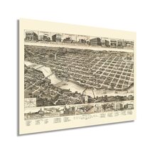
HISTORIX Vintage 1886 Columbus Georgia Map - 18x24 Inch Vintage Columbus Georgia
$39.99 - $59.99
View full item details »

Shipping options
Seller handling time is 1 business day Details
FREE via to United States
Return policy
Full refund available for DOAs
Details
Purchase protection
Payment options
PayPal accepted
PayPal Credit accepted
Venmo accepted
PayPal, MasterCard, Visa, Discover, and American Express accepted
Maestro accepted
Amazon Pay accepted
Nuvei accepted
View full item details »
Shipping options
Seller handling time is 1 business day Details
FREE via to United States
Return policy
Full refund available for DOAs
Details
Purchase protection
Payment options
PayPal accepted
PayPal Credit accepted
Venmo accepted
PayPal, MasterCard, Visa, Discover, and American Express accepted
Maestro accepted
Amazon Pay accepted
Nuvei accepted
Item traits
| Category: | |
|---|---|
| Quantity Available: |
16 in stock |
| Condition: |
New |
| ASIN: |
B093FQLXXY |
| Item Name: |
1886 Columbus Georgia |
| Item Type Keyword: |
artwork |
| Unspsc Code: |
60121013 |
| sizes: |
Listing details
| Seller policies: | |
|---|---|
| Shipping discount: |
Seller pays shipping for this item. |
| Posted for sale: |
April 27 |
| Item number: |
1742917484 |
Item description
Situated on the iconic Chattahoochee River banks, Columbus, Georgia, has an enduring history and place in the American South. Produced and published by one of the most prominent cartographers of the nineteenth century, Henry Wellge, this stunning birds-eye perspective allows the viewer a unique glimpse into the past with its distinctive style and attention to detail. At the Southwest border with Alabama Muscogee County, the region has been a significant driver for Georgia’s economy since its founding in 1828. By the latter portion of the nineteenth century, the agricultural economy had been replaced by textile and manufacturing jobs, earning it the nickname “Lowell of the South.”
Its proximity to the Chattahoochee River allowed it to export agricultural goods and manufactured commodities to the Gulf of Mexico, where they were then shipped to New Orleans for international export. The establishment of Fort Benning in the years following the conclusion of the Civil War also spurred on the local economy. Wellge’s career spanned more than five decades, and he is one of five cartographers credited with producing more than half of all birds-eye perspectives in the Library of Congress. Though he was based in Wisconsin, his depictions range from Maine to Texas.
Like much of the nation, Columbus was experiencing a boom of prosperity in the late nineteenth century as the United States entered the so-called ‘Gilded Age.’ Immigrants flocked to cities across the nation, establishing communities based on cultural lines, many of which exist to this day.
Our museum quality giclee print comes printed with archival ink on premium heavyweight matte paper. Shipped in a sturdy cardboard tube your print will arrive ready to be framed. This eye-catching vintage map reproduction print makes the perfect gift for anyone that loves history and imagery.
Loading
This item has been added to your cart
 HISTORIX Vintage 1886 Columbus Georgia Map - 18x24 Inch Vintage Columbus Georgia added to cart.
16 available in stock
HISTORIX Vintage 1886 Columbus Georgia Map - 18x24 Inch Vintage Columbus Georgia added to cart.
16 available in stock
View Cart or continue shopping.
 Please wait while we finish adding this item to your cart.
Get an item reminder
We'll email you a link to your item now and follow up with a single reminder (if you'd like one). That's it! No spam, no hassle.
Already have an account?
Log in and add this item to your wish list.