Rendered at 16:56:11 05/20/25


Shipping options
Offer policy
OBO - Seller accepts offers on this item.
Details
Return policy
Purchase protection
Payment options
PayPal accepted
PayPal Credit accepted
Venmo accepted
PayPal, MasterCard, Visa, Discover, and American Express accepted
Maestro accepted
Amazon Pay accepted
Nuvei accepted
Item traits
| Category: | |
|---|---|
| Quantity Available: |
Only one in stock, order soon |
| Condition: |
New |
| Type: |
Novelty Map |
| Original/Reproduction: |
Antique Original |
| Date Range: |
1800-1899 |
| Year: |
1855 |
| Country/Region: |
United States of America |
| US State: |
New York |
| Format: |
Folding Map |
| Printing Technique: |
Lithography |
| Cartographer/Publisher: |
University of the State of New York |
| Seller Notes: |
“Excellent condition with original folds” |
Listing details
| Seller policies: | |
|---|---|
| Shipping discount: |
Shipping weights of all items added together for savings. |
| Price discount: |
5% off w/ $75.00 spent |
| Posted for sale: |
More than a week ago |
| Item number: |
1234410297 |
Item description
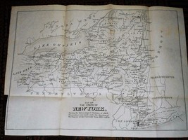
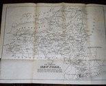
Map of the State of New York Shewing the Meteorological Stations at which Observations were made under the direction of the Regents of the University from 1825 to 1850
1855, The University of the State of New York
A rare folding map showing the location and prevailing average wind directions as recorded at meteorological stations in New York state from 1825 through 1850. This map was originally included in an 1855 publication, "Results of a Series of Meteorological Observations, Made in Obedience to Instructions from the Regents of the University, at Sundry Academies in the State of New-York, from 1826 to 1850". Unfolds to 14.5" x 11".
1855 New York State map meteorological stations 1825 to 1850, 14.5" x 11"
Click images to enlarge
Description
Map of the State of New York
Shewing the Meteorological Stations at which Observations were made under the direction of the Regents of the University from 1825 to 1850
1855, The University of the State of New York
A rare folding map showing the location and prevailing average wind directions as recorded at meteorological stations in New Yort state from 1825 through 1850. This map was originally included in an 1855 publication, "Results of a Series of Meteorological Observations, Made in Obedience to Instructions from the Regents of the University, at Sundry Academies in the State of New-York, from 1826 to 1850". Unfolds to 14.5" x 11".
Images sell!
Get Supersized Images Free Image Hosting
Create your brand with Auctiva's
Customizable Templates.
Attention Sellers - Get Templates
Image Hosting, Scheduling at Auctiva.com.
Track Page Views With
Auctiva's FREE Counter
Added to your wish list!
- 1855 New York State map meteorological stations 1825 to 1850, 14.5" x 11"
- 1 in stock
- Price negotiable
- Handling time 2 days. Estimated delivery: Wed, May 28th
Get an item reminder
We'll email you a link to your item now and follow up with a single reminder (if you'd like one). That's it! No spam, no hassle.
Already have an account?
Log in and add this item to your wish list.