Rendered at 16:49:52 05/17/25


Free Shipping
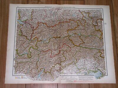
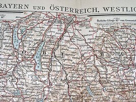
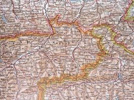
1930 ORIGINAL VINTAGE MAP OF BAVARIA MUNICH MAP ON REVERSE SIDE AUSTRIA TYROL
Ships from
Canada


Shipping options
FREE in United States
Ships from
Canada
Offer policy
OBO - Seller accepts offers on this item.
Details
Return policy
Full refund available within 30 days
Purchase protection
Payment options
PayPal accepted
PayPal Credit accepted
Venmo accepted
PayPal, MasterCard, Visa, Discover, and American Express accepted
Maestro accepted
Amazon Pay accepted
Nuvei accepted
Item traits
| Category: | |
|---|---|
| Quantity Available: |
Only one in stock, order soon |
| Condition: |
Acceptable |
| Maker: |
Andree |
| Type: |
Anthropomorphic Map |
| Date Range: |
1930-1939 |
| Year: |
1930 |
| Country/Region: |
Austria |
| State: |
Bavaria |
| City: |
Munich |
| Topic: |
Maps |
| Publication Year: |
1930 |
| Subject: |
SALZBURG |
| Original//Reproduction: |
Original |
| SHEET SIZE: |
22" x 17" (56 x 44 cm) |
Listing details
| Shipping discount: |
Seller pays shipping for this item. |
|---|---|
| Posted for sale: |
May 10 |
| Item number: |
1745921395 |
Item description
ORIGIN OF THE MAP: "Andree's Allgemeiner Handatlas", published in Leipzig, Germany by Velhagen Klasing.
DATE OF ISSUE: 1930.
SIZE: The sheet measures: 22" x 17" (56 x 44 cm). Size of the map of Munich and vicinity on reverse side: 11" x 8 1/2" (29 x 22 cm).
Most of maps we sell come from ancient atlases that were damaged and beyond repair. The maps have often a canvas or paper binding tape mounted on back along the centerfold. If you have ANY PROBLEM with the purchase, it is essential you CONTACT US BEFORE LEAVING FEEDBACK TO GIVE US THE CHANCE TO RESOLVE IT.
SHIPPED FROM CANADA in secure tubes or bubble mailers. PLEASE NOTE, THAT THE SHIPPING FROM QUEBEC TO THE U.S. TAKES 10 DAYS / WORLD 18 DAYS.
WE COMBINE SHIPPING COST FOR MULTIPLE ITEMS: THE POSTAGE FEE IS CHARGED FOR THE FIRST ITEM ONLY.
Added to your wish list!

- 1930 ORIGINAL VINTAGE MAP OF BAVARIA MUNICH MAP ON REVERSE SIDE AUSTRIA TYROL
- 1 in stock
- Price negotiable
- Returns/refunds accepted
Get an item reminder
We'll email you a link to your item now and follow up with a single reminder (if you'd like one). That's it! No spam, no hassle.
Already have an account?
Log in and add this item to your wish list.