HISTORIX Vintage 1869 Kankakee Illinois Map Poster - 18x24 Inch Old Map of Kanka
Shipping options
Seller handling time is 1 business day Details
This reflects the seller's handling time and may not include time spent in transit.
If you have questions about shipping, please contact the seller.
FREE via to United States
Return policy
Full refund available for DOAs
Details
- We guarantee our products and offer full refunds or exchange for defective items or items not as-described.
- Buyer must contact us within 30 days after receipt of shipment.
- The item must be received in the same condition as shipped.
- Items must be returned with all original packaging and accessories.
- Items must not be abused, modified or damaged by accident.
- A 20% restocking fee will be charged for returns
- Buyer is responsible for all return shipping and handling fees.
- Restocking and return shipping fees do not apply when item is returned as defective or because incorrect product was delivered.
Payment options
PayPal accepted
PayPal Credit accepted
Venmo accepted
PayPal, MasterCard, Visa, Discover, and American Express accepted
Maestro accepted
Amazon Pay accepted
Nuvei accepted
Item traits
| Category: |
Kitchen Scales
|
| Quantity Available: |
16 in stock
|
| Condition: |
New
|
| Color: |
Brown
|
| ASIN: |
B0BT7K26SV
|
| Bullet Point: |
View details
VINTAGE MAP REPRODUCTION: You’ll love this high quality historic reproduction of 1869 Kankakee Illinois Map Poster. Our museum quality prints are archival grade, which means it will look great and last without fading for over 100 years. Our print ...
|
| Product Description: |
View details
Produced and published by one of the most prolific cartographers of the bird's eye perspective genre, Albert Ru ger, this detailed panoramic map illustrates Kankakee in a period of significant growth and transition in the years following the co...
|
| Brand: |
HISTORIX
|
| Supplier Declared Dg Hz Regulation: |
not_applicable
|
| Item Name: |
View details
HISTORIX Vintage 1869 Kankakee Illinois Map Poster - Old Map of Kankakee Illinois Wall Art - Bird's Eye View History Map of Illinois Poster
|
| Item Type Keyword: |
prints
|
| Product Site Launch Date: |
2023-01-27T07:59:32.675Z
|
| sizes: |
View details
18x24 Inch (8 in stock)
24x30 Inch (8 in stock)
|
Listing details
|
Seller policies:
|
View seller policies
|
|
Shipping discount:
|
Seller pays shipping for this item.
|
|
Posted for sale:
|
May 1
|
|
Item number:
|
1743606997
|
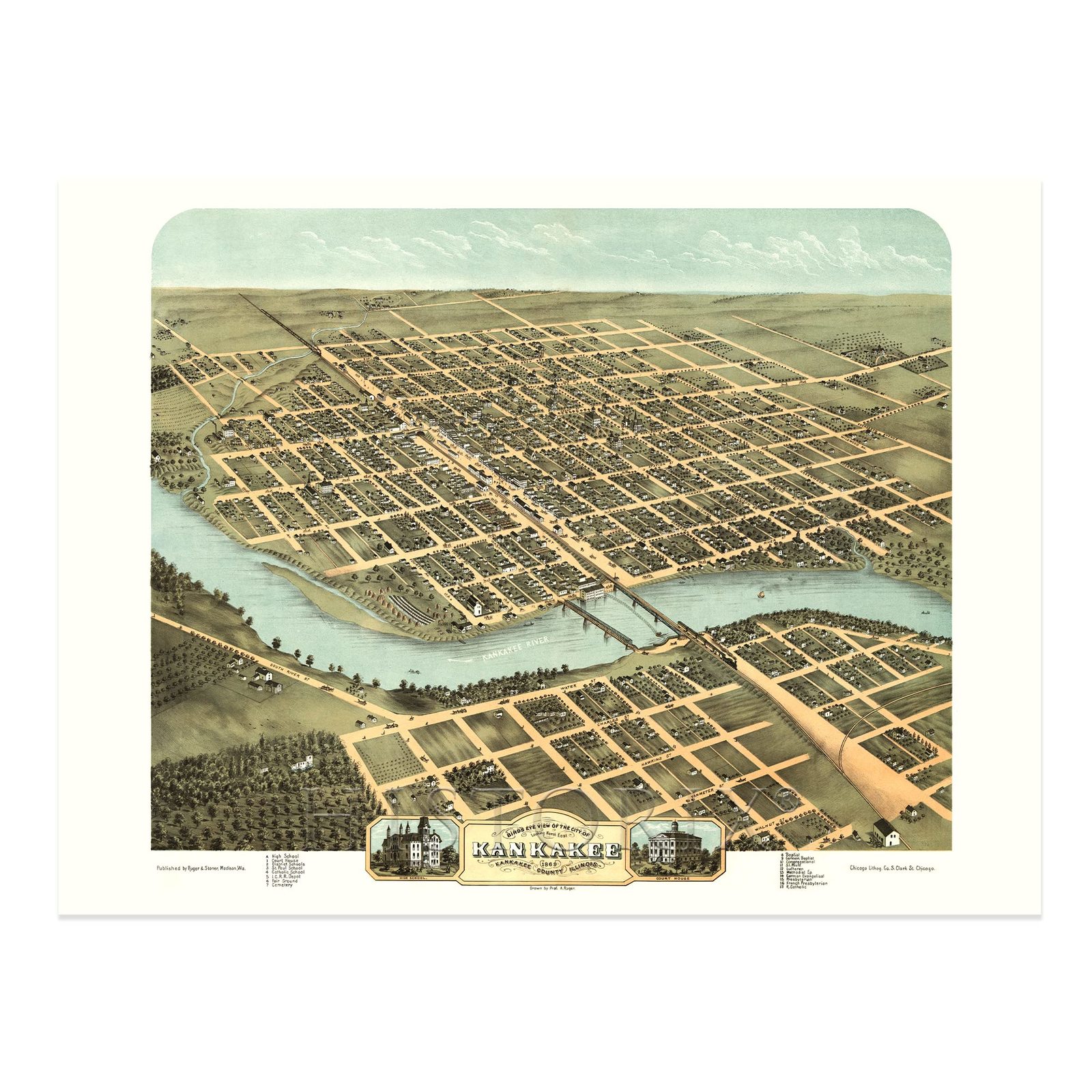
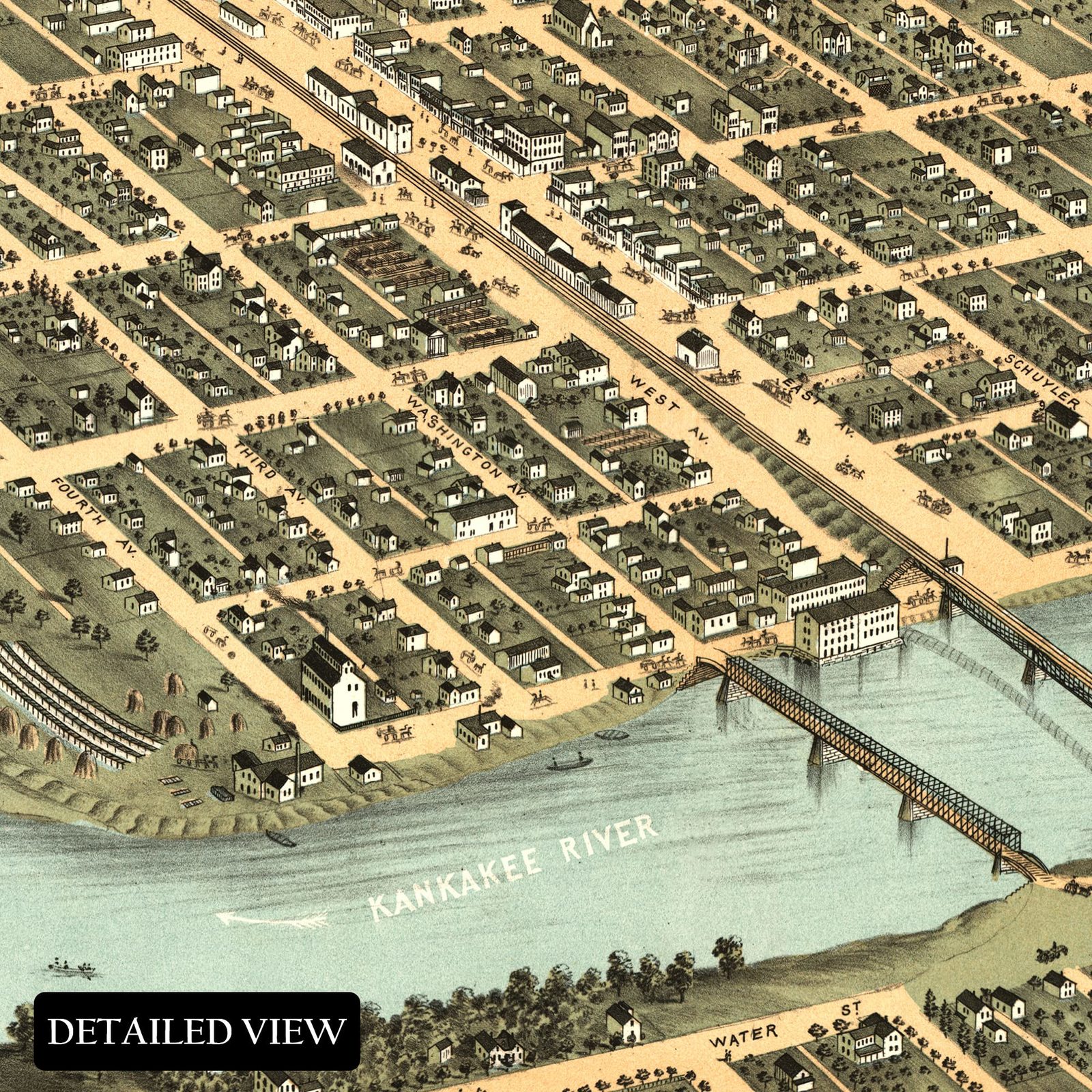
Produced and published by one of the most prolific cartographers of the bird's eye perspective genre, Albert Ru ger, this detailed panoramic map illustrates Kankakee in a period of significant growth and transition in the years following the conclusion of the American Civil War. Kankakee became an important anchor city in the rural plains surrounding the Chicago area. The town was founded in 1854, and this depiction marks the region's development through those years as manufacturing and its proximity to Chicago made the area a popular destination for residents looking to relocate from the American South as well as Western and Northern Europe.
Kankakee is situated at the confluence of the Iroquois and Kankakee rivers, which were essential trading routes during the early portions of the nineteenth century. The region experienced a significant increase in population during the latter parts of the 1800s as economic opportunities expanded and access was made possible with the establishment of rail lines across the North and Western United States. Kankakee is home to two iconic homes designed by notable architect Frank Lloyd Wright. The B. Hardey Bradley House and the Warren Hickox House which still stand to this day.
Albert Ru ger was a pioneer of the bird's eye perspective style, and his works are widely regarded as influencing the style, which became incredibly popular from the mid-nineteenth century until the 1920s when advances in aerial photography made the form obsolete. These highly stylized pieces of cartographical history immediately transport the viewer back in time.
Additional Details
------------------------------
Bullet point: VINTAGE MAP REPRODUCTION: You?ll love this high quality historic reproduction of 1869 Kankakee Illinois Map Poster. Our museum quality prints are archival grade, which means it will look great and last without fading for over 100 years. Our print to order maps are made in the USA and each map is inspected for quality. This beautiful artwork is a perfect addition to your themed decor. Vintage maps look great in the home, study or office. They make a perfect gift as well.
Product description:
Produced and published by one of the most prolific cartographers of the bird's eye perspective genre, Albert Ru ger, this detailed panoramic map illustrates Kankakee in a period of significant growth and transition in the years following the conclusion of the American Civil War. Kankakee became an important anchor city in the rural plains surrounding the Chicago area. The town was founded in 1854, and this depiction marks the region's development through those years as manufacturing and its proximity to Chicago made the area a popular destination for residents looking to relocate from the American South as well as Western and Northern Europe.
Kankakee is situated at the confluence of the Iroquois and Kankakee rivers, which were essential trading routes during the early portions of the nineteenth century. The region experienced a significant increase in population during the latter parts of the 1800s as economic opportunities expanded and access was made possible with the establishment of rail lines across the North and Western United States. Kankakee is home to two iconic homes designed by notable architect Frank Lloyd Wright. The B. Hardey Bradley House and the Warren Hickox House which still stand to this day.
Albert Ru ger was a pioneer of the bird's eye perspective style, and his works are widely regarded as influencing the style, which became incredibly popular from the mid-nineteenth century until the 1920s when advances in aerial photography made the form obsolete. These highly stylized pieces of cartographical history immediately transport the viewer back in time.