HISTORIX Vintage 1896 Map of Louisiana - and 50 similar items


Free Shipping
HISTORIX Vintage 1896 Map of Louisiana - 18x24 Inch Vintage Map of Louisiana Wal
$39.99 - $59.99
View full item details »

Shipping options
Seller handling time is 1 business day Details
FREE via to United States
Return policy
Full refund available for DOAs
Details
Purchase protection
Payment options
PayPal accepted
PayPal Credit accepted
Venmo accepted
PayPal, MasterCard, Visa, Discover, and American Express accepted
Maestro accepted
Amazon Pay accepted
Nuvei accepted
View full item details »
Shipping options
Seller handling time is 1 business day Details
FREE via to United States
Return policy
Full refund available for DOAs
Details
Purchase protection
Payment options
PayPal accepted
PayPal Credit accepted
Venmo accepted
PayPal, MasterCard, Visa, Discover, and American Express accepted
Maestro accepted
Amazon Pay accepted
Nuvei accepted
Item traits
| Category: | |
|---|---|
| Quantity Available: |
16 in stock |
| Condition: |
New |
| ASIN: |
B086YZKR6T |
| Item Name: |
HISTORIX 1896 Louisiana Map |
| manufacturer: |
Historix |
| Item Type Keyword: |
prints |
| Brand: |
HISTORIX |
| Unspsc Code: |
52140000 |
| sizes: |
Listing details
| Seller policies: | |
|---|---|
| Shipping discount: |
Seller pays shipping for this item. |
| Posted for sale: |
May 1 |
| Item number: |
1743622961 |
Item description
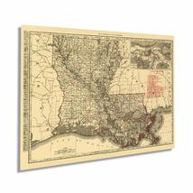
Produced by the prolific mapmaker Rand Mcnally, this railroad and transportation map of Louisiana in 1895 depicts the state in a time of great transition as reconstruction and the turn of the century approached. The Mississippi River had long been a crucial trade route for getting goods into the midwest. The main entry at New Orleans had kept the iconic American city thriving, and the 1890s were no different. People from across the globe came through the city, and its French roots mixed with local Creole culture had developed into a distinct melting pot found nowhere else.
During the Civil War, the capture of the Mississippi by Union forces marked a turning point in the war, and Union victory became apparent due to the significant importance of the river to Confederate forces. The late 20th century saw significant advances in shipbuilding, and the proliferation of locks, levees, and dams along the river started. Much of this engineering occurred to keep the river from shifting into the Atchafalaya River, thus bypassing New Orleans.
The acquisition of Louisiana, as negotiated in 1803, included a vast amount of North American territory. France was engaged in multiple conflicts and needed capital to finance these clashes, allowing the new nation to acquire 828,000 sq mi of land for fifteen million dollars. The purchase would become a pivotal part of the American notion of Manifest Destiny and redefine the geography and geopolitical landscape of America. This map is truly an authentic piece of cartographical history.
Our museum quality giclee print comes printed with archival ink on premium heavyweight matte paper. Shipped in a sturdy cardboard tube your print will arrive ready to be framed. This eye-catching vintage map print makes the perfect gift for anyone that loves history and imagery.
|
Why are we showing these items?
Booth
Historic Prints |

|


-
Refine your browsing experience
We can show you more items that are exactly like the original item, or we can show you items that are similar in spirit. By default we show you a mix.


This item has been added to your cart
 HISTORIX Vintage 1896 Map of Louisiana - 18x24 Inch Vintage Map of Louisiana Wal added to cart.
16 available in stock
HISTORIX Vintage 1896 Map of Louisiana - 18x24 Inch Vintage Map of Louisiana Wal added to cart.
16 available in stock
View Cart or continue shopping.
 Please wait while we finish adding this item to your cart.
Get an item reminder
We'll email you a link to your item now and follow up with a single reminder (if you'd like one). That's it! No spam, no hassle.
Already have an account?
Log in and add this item to your wish list.